Area Maps
 Back Back
 Bottom Bottom
Central and Southwestern Pacific Ocean
 Central and Southwestern Pacific Ocean © 1996 Brandon Plewe
Back
 Top
Bottom Top
Bottom
Papua New Guinea, the Bismarck Archipelago and the Western Islands
 Papua New Guinea, the Bismarck Archipelago and the
Western Islands
Papua New Guinea, the Bismarck Archipelago and the
Western Islands
Back
Top
Bottom
War time map of The Bismarck Archipelago
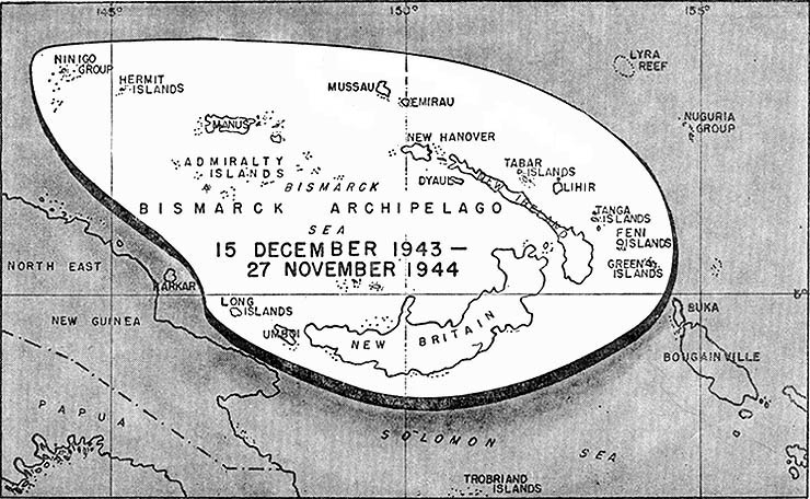 War time map of the Bismarck Archipelago and some of the
Western Islands (Wuvulu, Aua, Manu and the Anchorites islands are not shown)
War time map of the Bismarck Archipelago and some of the
Western Islands (Wuvulu, Aua, Manu and the Anchorites islands are not shown)
Source: U.S. Army Center of Military History - War Department, March 1947, General Order No. 24, CAMPAIGNS, WORLD WAR II-List of battles and compaigns, ASIATIC-PACIFIC THEATER, 14. Bismarck Archipelago. (Fig. 14.)
Back
Top
Bottom
The Western Islands and
Manus Island
Back
Top
Bottom
The Western Islands
![The Western Islands of the Bismarck Archipelago [FRB map]](images/map-western-islands.gif) The Western Islands
The Western Islands
Back
Top
Bottom
Early Maps
 Descripcion de las Indias del Poniente by Antonio
de Herrera, Madrid 1601
Descripcion de las Indias del Poniente by Antonio
de Herrera, Madrid 1601
The oldest known map of New Guinea and the Western
Islands
 Nova Guinea—The First Map of New Guinea, 1600 • Portuguese Hemisphere (left) and Spanish Hemisphere (right)
from George Collingridge de Tourcey's 1906 "The First Discovery of Australia and New Guinea"
Back
Top
Bottom
Links to Maps of Interest
When you visit linked sites, use your rowser "Back" button to return here.
Notice regarding Links: See Terms, Links
Back
Top
|
![The Western Islands & Manus Is. [FRB map]](images/map-western-islands-manus.gif)